The Wild West: Bajhnag to Humla via foothills of Mt. Saipal
The Wild West Bajhang to Humla is one of the most remote and exotic treks in Nepal. This trek is an ideal trek for those adventure lovers who seek a very remote and exotic trek in Nepal. It is also a rarely visiting trek in Nepal.
The idea of the trip
This adventure trip starts from Bajhang district headquarter Chainpur after a long drive from Dhangadi (a far western hub).
For simplicity the trek is divided into three parts:
1. Chainpur to Urai La Pass
2. Urai La Pass to Chhala– A wild immersion
3. Chhala to Simikot
The first part of Trek: Chainpur to Urai La Pass
The trek starts from the roadhead at Talkot/Rupatoli & follows the Seti Nadi along the Urai La trail for the first 6 days till one reaches Urai La Base camp.
The trail crosses the villages of Sunpani, Kuwa, Dhalaun, Bajchauka, Kaya till one reaches the last village of Laphri/Dhuli and is on the true left of Seti Nadi till its confluence with the Syanban Khola. Enroute after Dhalaun (which has some homestays) one crosses the ridge of Binayak Nagna Bhanjyang and then descends onto Kagarkot (which also has a couple of rudimentary homestays).
From Kagarkot, the trail descends to the Seti Nadi and then ascends to the villages of Bajchauka (which has a hotel), and then descends again to a couple of grazing grounds an hour before Laphri. From Laphri the trail ascends again and descends to Syanban khola, where it crosses a bridge. After crossing the bridge at Syanban Khola, there are the beautiful meadows at Chauraphani Phat, a nice camping site.
From Chauraphani Phat one continues eastwards along the true left of the Seti Nadi, often contouring high above it, crossing a temple, and reaching Naya Odar, where there is a bridge across the Seti Nadi leading to a route from Nilkhatti Khal. From Naya Odar the route continues onto Dahachaur, the confluence of Seti Nadi with Gaisar Khola. From Dahachaur the route continues northwards along a valley that is narrow initially and then broadens out towards Graphu Odar.
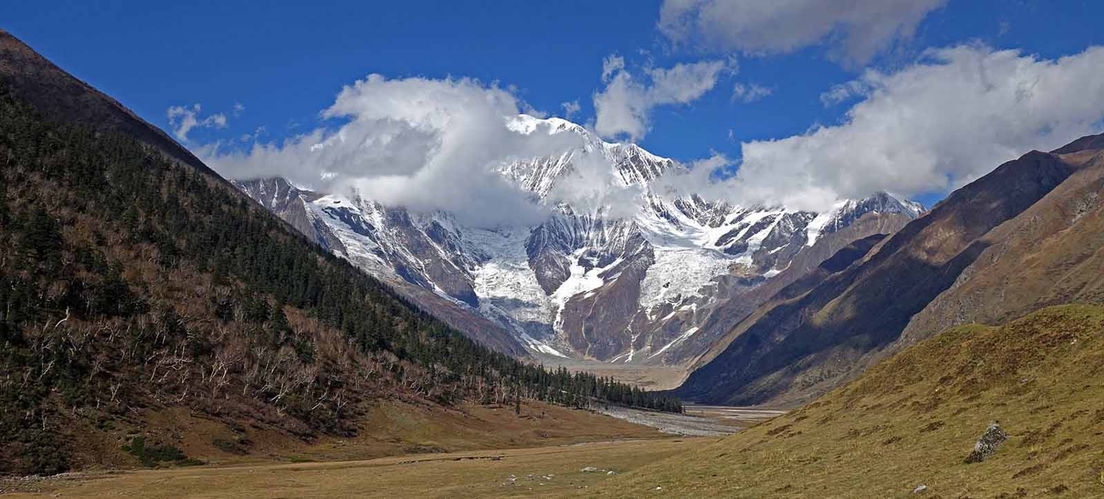
From Graphu Odar the trail contours onto the meadows at Saipal, at its confluence with the Raksha Urai Khola. Here one has to cross the side stream originating from Karka Lek and continue along Seti Nadi to another meadow (locally known) as Khalanga. During Yarsagumba season at Syanbang Khola, Naya Odar, Dhachaur, near Graphu Odar and Khalanga one can find temporary hotels. From Khalanga, it is a steep ascent along the sides of a glacial moraine to the base of the Urai La.
The second part of Trek: Urai La to Chhala (An immersion in wild)
The second part of the trek is an immersion into the wild. In this section, there are no villages at all for seven days.
From Urai La base camp the route to Chaupa Col is not very clear. The route is along the Salukhane Khola, which was a dry nala. The route is covered with boulders and shale.
One can also go along the dry bed of the Khola but the last 150M or so would then have to be a scramble on loose shale. So, I stayed on the slopes on the true right (i.e left of the valley as we climb up) of the khola and climbed well above the height of the pass on the slopes and then descended onto the pass, thus avoiding loose shale as much as possible.
The pass is the lowest point on the ridge between Chaupha Tuppa (5506 M) and pt 5456 (as marked on the map) and is marked by cairns. From the ~5200M pass, the descent is onto a boulder field. Try to keep to the left of the boulder field (to avoid too much boulder hopping) followed by a short sharp descent to the stream originating from Chaupa Tuppa. Continue following this stream keeping to its true left initially.
After a short walk, cross over to the true right of the stream to descend the ridge into the valley. There is no clear trail. The descent is in the direction of the "red/pink" stone/rock face on the valley facing you. If one tries to descend on the ridge, on the true left of the khola, one encounters steep rock faces, waterfalls where one will not be able to descend (as I discovered). After the descent follows the khola downstream till its confluence with Thado Khola. Here there are beautiful campsites.
From the campsite at the confluence, walk upstream in a north-westerly direction, along the true left (i.e cross the valley to its right) of the Thado Khola. There is a shepherd's trail here. It is a ~4-hour walking distance to Thado La (~5308 M). As one reaches an altitude of ~5000 M one needs to head north along with the side stream feeding into the Thado khola (instead of following the khola further northwest).
During the ascent to Thado La one would have to traverse a boulder zone, where the trail is not well marked. Thado La is the lowest point on the ridge between points 5510 and point 5482 (as marked on the map) and is indicated by stone cairns/prayer flags on the ground. From Thado La one can get good views of Tibet.
From the camp at the confluence, one can follow the Thado Khola downstream keeping to its true right. There is a well-marked shepherd's/foot trail that should be clearly visible. To get onto it, cross the khola at the confluence onto its true right and ascend onto the trail. The trail contours high above the Thado Khola. One will have to cross a few side streams feeding into the Thado Khola till one reaches a small shepherd's bridge (wood and stones) across the Thado Khola. During the yarsa gumpa season (like in this trek) one can spot a few yarsagumpa tents here. This is a good place to camp. From this log bridge/campsite there is a spur that has to be crossed to get into the Syanbang Khola. The climb is about 600M and is very steep.
After getting atop the first spur (marked by a cairn), there is a perilous looking narrow trail (one slip/misstep here looks fatal - as it is a 200M slide to the khola at the bottom) which one has to cross to traverse across to reach the top of the 2nd and 3rd spurs marked by cairns. From the top of the 3rd spur, marked by cairns, it is another steep descent on loose rock to reach the Syanbang Khola. From the top of the 3rd spur, one can see the Syan Taal. There are campsites on the true right of the Syanbang Khola. However, cross over to the true left using a shepherd's bridge (stone and rocks) towards the Phirankoph Chula and there are huge meadows there. This campsite locally is known as Raidunga. These meadows have a lot of shepherd encampments and there is good clean water here. These shepherds are from Limi Valley as this grazing region belongs to Humla.
The Thado Khola valley grazing region belongs to Bajhang. The water of the Syanbang Khola looked brown and did not seem potable. One can get beautiful views of the Phirankoph Chuli from this camping site. It takes about 3 hours to cross the spur and there is no water in between so it is advisable to take water from the Thado Khola campsite before crossing this steep spur.
From the campsite at Raidunga, one heads north along the Syangbang Khola and then turn in a north-easterly direction along the first major Khola. There is no clear trail here but one just needs to follow this khola, initially on its true right and after a short distance crossing over to its true left. There is another clearly marked trail that heads along the Syanbang Khola, that is frequently used by locals coming from Limi to Raidunga, which leads to Yansi Gumpa.
The route continues along a north easterly direction on the true left of the khola. The initial narrow valley broadens out and the route then heads in a south-easterly direction along the khola to the Zimgang/Toibun La. The approach to Toibun/Zimgang is along a fairly gentle ascent and the last 100M or so is along a faint trail across a rock/boulder strewn face. There is a trail for mules here, but is not easily discernible. If one misses the trail, like I did, one will end up climbing/clamberig over avoidable and dangerous rock faces to the Zimgang LA /Toibun pass (5332 M), which is marked as Pt 5310 on the map. The pass is marked by cairns/prayer flags. The descent is in a south-easterly direction towards a khola, along loose rocks. After a 350M descent is a beautiful glacial lake called Karan Taal. It is a nice place to camp.
From Karang Taal one follows the Karang Khola. There is a hardly discernible trail along the central ridge as one descends along the khola. Descending from any other ridge on the right/left seems dangerous. There are great views of the North Saipal Glacier and Saipal as one descends to Karan Khola. The route follows along the true left of the Karan Khola. In season, it is possible to see yak herders, from Chala village, enroute at Thang Chobu (local name).
From Thang Chobhu the route descends to Karan Khola in an easterly direction and ascends again in a north-easterly direction, toward the confluence of the Karan Khola with Kolunba Khola (flowing from the direction of Chala), crossing a ridge and then descending in a northerly direction, crossing a bridge over a side stream/khola before the final steep and arduous ascent to the village of Chala.
The last part: Chhala to Simikot
The last part of the treks is an easy trail from Chhala village to Simikot. From flyout to Nepalgunj and Kathmandu.
The feature of Wild West trek
After the Laphri of Bajhang on the way to Urai la trail, and before one reaches Chala (Humla District) there are no villages for 7 days. That’s why it is a complete wilderness trek in West Nepal.
During the yarsagumba season, like in June, one may find temporary hotels on the Urai La trail. In addition, one may find goat/sheep herders/yak herder's camp en route.
This is a journey across 4 high altitude passes ( Chaupha Col, Zimgang La aka Toibun, Nyalu La, Pt 5448 pass ), exploration of 4 passes leading to Tibet ( Thado La, Lapche La , Lolun Bhanjyan & an unnamed pass), a couple of beautiful high altitude glacial lakes (Karan Tal, Chhyolomyok Tal), several valleys ( Seti Nadi, Thado Khola, Phirankoph Khola, Syanban Khola, Karan Khola, and majestic mountain vistas ( Phirankoph Chuli, and North Saipal).
