
Himalayan Companion’s Wild West Trekking is five week long journey that immerses into the wild and least explored valleys of North-West Nepal. This trekking trip caters to the impressive nature of the western Himalayas as well as the diversified culture of the hospitable people of this remote mountain region. Wild West trekking takes place near the Tibetan-Chinese border Kangla and foothills of Kanjiruba massif.
Trip Profile
Start point: Khalanga Jumla
Trip Type: Camping
No.of Trekkig day: 27
Highest Point: Kanja La or Ge La 5200m
Route: Khalanga, Rara Lake, Changkheli Lekh, Nepka village, Kang La chaur, Mugu village, Dolphu, Namlang River, Bhot Khola, Talphi, Jumla
Trip Grade: Strenuous
End point: Jumla
As usual, we divide our trip into several stages as following;
Stage 1 Nepalguj to Khalanga camp at Chyarechaur and trek to Rara Lake
Stage 2 Rara lake passing Changkheli Lagna to Nepka village
Stage 3 Nepka village Passing Mugu Dada 4987m to Mugu village
Satge 4 Mugu village to Dolphu village along the Mugu karnali and Namlang River
Stage 5 Ascents to the High Mountain, immersion in to foothill of Kanjiruba Himal
Stage 7 Talphi to Jumla back to Civilization
Details of story………..
Stage 1
Nepalguj to Khalanga camp at Chyarechaur and trek to Rara Lake
Nepalgunj is a town in Southern Nepal (Terai), but is the hub for flying in/out the highlands of Western Nepal. The flight takes up from Nepalgunj150m to Jumla Khalanga 2540m, grazing on the great Himalayan range of Western Nepal. The 25 minutes time inside the flight get past easily experiencing window views of the great Himalayan range.
After landing at Jumla Khalanga we kick start the first-day trek about an hour to Chyarechaur. From the next day, we trek full day for four weeks long journey into the wilderness of West Nepal. The first part of the trek is the classic Rara Lake Trek.
Leaving the Chyarechaur we take the western route following the lush vegetation to the Jaljala Chaur 3420m an amazing camping spot. The beautiful morning starts with descending down to Sinjha valley along with the dense vegetation, clear rushing streams, and scattered settlement of Hindu Khas villages. Soon crossing a suspension bridge above the Tila River we enter to Sinjha valley and stop few hours for Lunch. Sinjha valley was the Kingdom of ancient Khas dynasty. After lunch, we resume our trek to Bota and from here the trail bends to the east through the Dhuli Khola river bank and beautiful vegetation the next is Chauta. For the next two days, we come across the Gurchi Lagna 3445m via Bulbule Checkpoint to the Pina before Rara Lake.
Stage 2
Rara lake passing Changkheli Lagna to Nepka village
In this stage, we leave the Rara Lake and descend down to Luma through Gamgadi the capital of Mugu district and ascend to Bam. The next day we camp at the top of Changkheli Lek and we get an amazing view of the surrounding Mountains. Soon Passing the Changkheli Lek 3594m our next camp is Melchham Bagar. From here our trail switches to the north after crossing a suspension bridge at Piplan and we follow the Loti Karnali River up to the Nepka village via Mathillo Pali and Chhala.
Nepka is an extremely remote village in Humla district. It is the home of indigenous Tamang people but unfortunately, they have lost their language and their own culture. These days they are completely in the domination of Hinduism.
Stage 3
Nepka village Passing Mugu Dada 4987m to Mugu village
After leaving the Nepka village we engulf into the wilderness for a week before reaching Mugu village. We follow the Loti Karnali River along the lush vegetation of Lepcha, Galangna and Chungar Chaur, relaxing and enjoying breathtaking views. Beyond the Chungar Chaur the trail heads through the Tanke Khola and gradually leads to the treeless barren pasture near the Tibetan border Kangla of Tanke Kharka. We set our camp for the first time at the altitude of 4500m at Kang La Chaur, from Kangla Chaur a trail eventually branches off to the left which leads to Tibet crossing Kang La, whilst our trail continues up to the right side of the valley. A day excursion up to Kang La and view the other side (Tibet) could be worthwhile. And next morning trails switch to the eastward ascending Mugu Dada ridge 4987m which separates the Chawarsing khola valley and Takya Khola valley. Descending initial steep down from the ridge, it is easy to walk down the valley of Takya khola and further descends down to its junction with Nangja Khola(the valley leading up from Mugu to the Namja Bhanjyang) where we stop for camp. From here trail passes through the flat valley of Mugu Karnali River all the way to Purano Mugu and Mugu village.
Mugu is a small mountain village located in the Northwest Himalayas of Nepal. The inhabitants of Mugu village are known as ‘Mugum’ Mugu dates back about 800 years. Mugu village is one of the isolated and remote places of Karnali zone. Having tough topography they were Himalayan traders for many years and followed trans-Himalayan trading and males were spending about 8 to 9 months out of the village. However, these days due to a valuable Himalayan gold rush ‘Yarsagumba’ the trans-Himalayan trading had shifted to wide-ranging commodity exchange and many people had become economically sound. Only a few people live in villages and during winter almost all the people migrate to lower valleys and also in Jumla, Surkhet, Nepalgunj, and Kathmandu.
Stage 4
Mugu village to Dolphu village along Mugu Karnali river and Namalang River
This part of trek is quite easier whereas we follow the Mugu Karnali back downstream via Shailenkharka and full path to the confluence of the Mugu Karnali and Namlang River. There is, solitary and alone, Tyar Gompa, the most beautiful Gompa on our way.
After crossing the river above the junction with Namlang Nadi, trail ascends steadily to reach the delightful Kimri village. From here, a good but long trail traverses the hillside high above the Namlang River through Kartike and towards Dolphu village.
Beyond the Kartike the track leads to the narrower Namlang River valley, the edges become steeper gorges. And the trail winds turned a hundred meters above the rushing river through the steep cliffs. Hour and hours uphill and downhill following the narrow path with long day hike is awaited Dolphu village.
Stage 5
Ascents of the High Mountain
Leaving the Dolphu the trail ascends into the wilder and uninhabited mountains through the 700m downhill to Namlung River and crossing a quite narrow and a bit rotten bridge. Soon we get into a beautiful meadow near the Wangri and stop for lunch.
After the lunch break, we further follow the beautiful meadow and set our camp at Wangri. Wangri was a mountain village like other villages but a few years back the last inhabitants were gone away and now it has become a ghost town.
Leaving the Wangri the trail passes through a wonderful birch forest and conjoins in the valley of Raphu Khola. Soon reaching 4000m tree line leads into the treeless high mountains and we set up the camp valley below the pass.
Stage 6
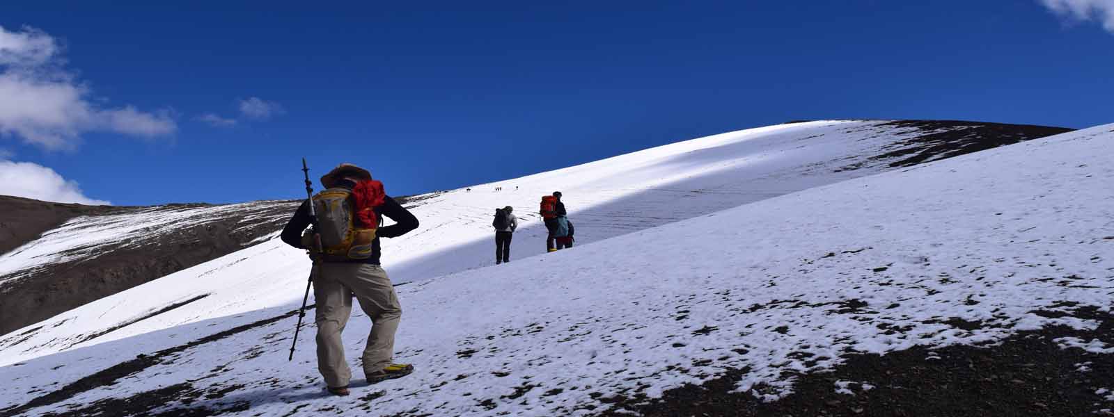
Three days in three high passes Kanja La or Ge La (5200m), Dolphu Kang (5000m), and Talphi La (4600m)
For the three days, we sink into deeper and deeper Highland wilderness on the foothill of Kanjiruba massif. We come across traversing three high passes like Kanja La or Ge Lekh 5200m and Dolphu Kang 5000m, and Talphi La 4600m.Climbing to Kanja La is quite steep and strenuous which is leads through the stone debris and gravel track causes the with each step upward slipping back down but the surrounding views of mountains reward the during the climb.
Ascending to Dolphu kang will be another adventurous day for us. Ascending to Dolphu Kang is not torturous as Kanja La because of as we are acclimatized to the altitude on one hand and on the other hand the trail is not rough as Kanja La. Though there are no glaciers or snow views the magnificent green plateau and steep path are breathtaking.
For the last time once again we will climb up to Talphi La 4600m altitude, it passes via beautiful Mountain Lakes and the last prayers flag on the pass farewells our trip. Soon we descend to through downhill about 1700m and hike along the forest is Talphi village.
Stage 7
Talphi to Jumla back to Civilization
The trail from Talphi to Jumla is far, but easy and simple. We follow the broad and densely populated River valley downstream, passing through numerous villages. There are many people on the go, they go about their daily work after. We can observe the Children are going to school; women are washing clothes in the river, men are building a house, a boy who captures a runaway cow.
Finally reaching Jumla…….
Today is our last night with the crew, from tomorrow no more trekking. The following day we catch the flight to Nepalgunj and Kathmandu. In the end, we go for farewell dinner in Nepali typical restaurant and in Kathmandu and end of your holiday project into the wilder west Nepal.
Level of Participants;
This trekking trip is a bit longer which will be three weeks long journeys in Wild West Nepal and a good level of fitness is needed for this trip.
This is a journey into the wilderness and a good dose of patience, tolerance, and humor are needed.
Why with Us?
We are a west Nepal specialized tour operator and native of West Nepal.
We had organized many novice trekkers in the region and have experienced trekking crews.
At last but not least, our priority is on local staff, so community people will be directly benefited.
Have a great holiday in West Nepal!


